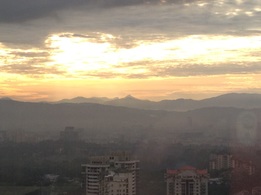
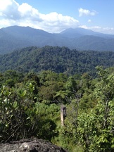
 View of the east from the peak of Bukit Kutu. The chimney of the 1st bungalow can be seen below. In the background is Gunung Rajah
Malaysia, Selangor, Kuala Kubu Bahru
1058m | 6.8 km | 3:44 hours
Bukit Kutu, formerly known as Treacher's Hill is an abandoned colonial hill station just upstream of the original Kuala Kubu town (now known as Kampung Ampang Pecah). It has an interesting history, the hill station was founded in 1893 by William Hood Treacher, resident of Selangor, whilst on a working tour of Kuala Kubu and surrounding districts. There were supposedly two bungalows at the top which functioned as a health retreat for the British administrators. A bridle path (horse or donkey trail) connected it to the old Kuala Kubu town. The hill station fell into disuse after the more prominent Frasers Hill was re-developed into a hill station and opened to the public in 1922. During the Japanese invasion in 1942, the British army supposedly destroyed the bungalows as they retreated ahead of the advancing Japanese forces. All that remains today are the chimney and veranda steps of one of the bungalows. There is another sturdier structure on the Kuala Kubu side of the peak. Most refer to this as the "sanatorium" and some call it the 2nd bungalow. I think the whole hill station is referred to as the "sanatorium" by the British as similar references can be found for the Penang and Maxwell hill stations. I do not think there was actually a building or hospital of some sort called "sanatorium" at Bukit Kutu. I also am somewhat sceptical of the notion that this building was the 2nd Treacher's Hill bungalow. The first bungalow was a wooden building with brick steps, fireplace and chimney. Several photographs of the first bungalow survive. As mentioned, very little of the 1st bungalow remains but the identity of the bungalow can be of no doubt due to the distinct fireplace, chimney and the mountain views that form the backdrop to the bungalow in the old pictures. In contrast, much more of the 2nd structure remains, including stone walls, arched doorways and steps. It's an altogether bigger structure and much more stout and sturdy in appearance. The walls are thick, far thicker than what we see in brick bungalows from that period even in towns. There doesn't seem to be any sound merit for its strong walls especially considering the additional effort of carrying building material and workers 1000m up into the hills. I am of the opinion that this building is a fort or defensive structure of some kind, either built during World War 2 or a structure from an even older period, perhaps even before W. H. Treacher's visit to the hill in 1893.