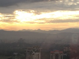
 Long distance view of Gunung Besar Hantu from Kuala Lumpur. It's the tallest peak in the centre of the picture
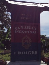
Malaysia, Negeri Sembilan, Jelebu
1462m | 18 km | 8:16 hours
Gunung Besar Hantu is the highest mountain in Negeri Sembilan, but as far as tall mountains in Malaysia go, at 1462m, Besar Hantu is relatively low. All other states, apart from Perlis, Penang, Melaka and Johor, claim loftier peaks with even Kedah having as its tallest peak a 1862m mountain called Bukit Bintang. Still, it was a hard climb and certainly one of the hardest I have attempted in my rather short climbing "career".
Even getting to the mountain was quite a challenge. It's located in Jelubu district on the northern extreme of Negeri Sembilan, right on the border between the state and Pahang. We drove from KL to to Ulu Langat, and from there attempted to drive via Jalan Sungai Tekali to the Hulu Langat reservoir where we then skirt the lake around the north before joining the Sungai Lui road to the south east across the border via Genting Peres into Negeri Sembilan. Nature however threw us a bunch of spanners. Firstly the Sungai Tekali road was damaged just after Taman Titiwangsa and was constricted to a single lane dirt road for a couple of kilometres. As we had a 4WD, we overcame that challenge but later discovered that the road around the reservoir was totally blocked due to landslides.