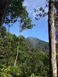
 View of the Keledang peak from along the tarred road
Malaysia, Perak, Mengelembu
813m | 11.1 km | 4 hours
Bukit Keledang is the highest peak in the southern part of the Keledang Mountain range. It's situated between the Kinta and Perak river valleys and frames Ipoh on the western side. Given it's location between two river valleys, and open flat land on the southern side, I expected it to offer unobstructed views of the mountains in the Main range as well as the mountains on the Bintang/Bubu range. And Keledang didn't disappoint.
At the peak, there is a plethora of telecom and TV broadcast towers with the highest point being occupied by an RTM antenna. In addition to many recreational paths at the foot of the mountain, there are 3 routes that lead to the peak. The first is a paved access road for the various telecom towers. This is the longest, but as you can imagine, the least steep route. It starts from Jalan Keledang and twists its way all the way to the top. It has the best views.

