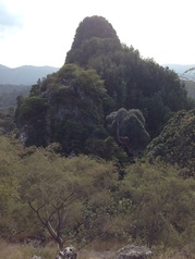
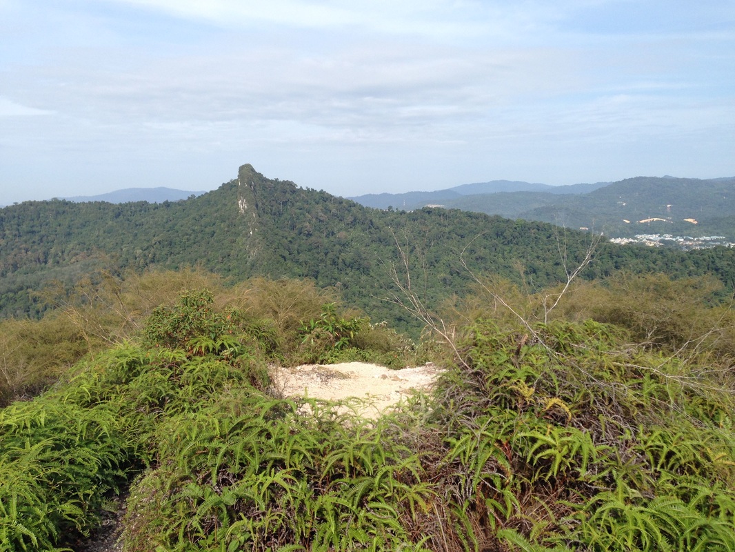
 View of Peak #4 of Bukit Tabur East from the the first peak. There is a drop to the tree area below from where the climb for Peak #4 starts
Malaysia, Kuala Lumpur, Taman Melawati
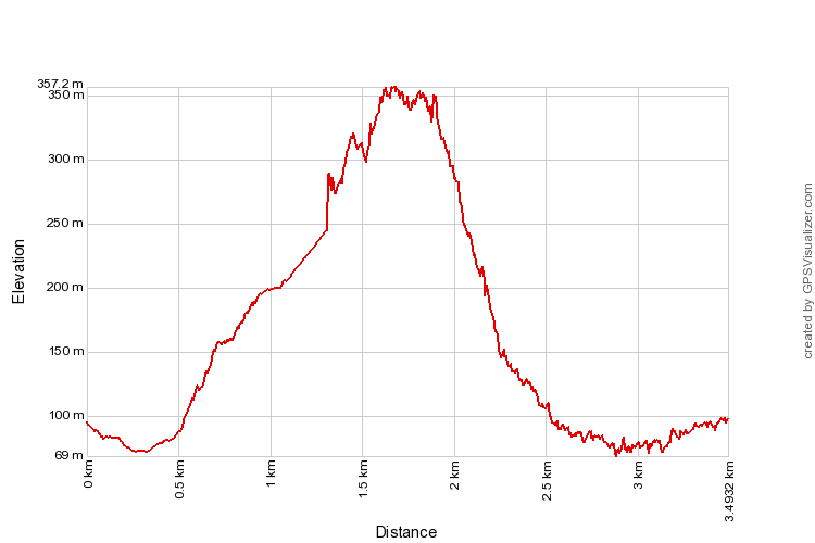
400m | 3.5 km | 3 hours
Anyone who has gazed out from a tall building or high point in Kuala Lumpur would not have failed to notice the white cliffs that surround the northern edge of the city, like a white veil shielding what's beyond from the prying eyes of KLites. Many assume that the cliffs are limestone hills, like the ones that dominate the Ipoh or Phuket skyline. But despite what it looks like from the city, the KL "cliffs" are not exposed sides of limestone hills, but actually a long and narrow ridge made of exposed quartz with steep drops on both sides where the surrounding non-quartz soil has been worned down by the weather. It's only when seen from the top of the ridge itself that one is able to fully appreciate how narrow the ridge really is and marvel at the incredible fan-like nature of the ridge. The views from the peaks are truly amazing and even as one is making the ascent, you cannot help but think how on earth one even reaches the thin, precarious peaks that stretches far out to the horizon like some kind of a spine on the back of a gigantic pre-historic dragon.
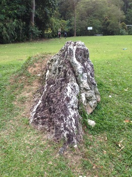 Itsy-bitsy peak on the field next to the river bank. The ridge worn down to just 2 feet high!
The ridge is the longest exposed quartz formation anywhere in the world, an almost straight line stretching from near Rawang in the north to Bukit Langong and then to Taman Sri Gombak, Klang Gates, and eventually to the hills beyond Zoo Negara, a distance of some 16km. The ridge is broken in several places forming gateways where the jungles beyond the ridge could be accessed. One such break is where the Gombak river flows through and is where Jalan Gombak, the original trunk road to Pahang is located. Another break is the narrow pass where Sungai Kelang flows through. This is where the Klang Gates dam was built in the late 50's to supply water to the rapidly expanding city. The retaining dam walls form a large lake in the watershed jungles behind the ridge. The ridge to the left and right of the Kelang River break is called Bukit Batu Tabur. I can't help wondering if it's called such because the hills have lumps of exposed quartz rock spread out in a long line ("Bukit Batu Tabur" in Malay literally means Spread Rock Hill). The ridge on the left (as one reaches the dam from the city) is called Tabur East while the one on the right is called Tabur West.
Tabur West is the more popular climb even though it is the longer and higher hike. Tabur East is just as challenging (some would say even more challenging) and rewarding, made no less enjoyable by its smaller crowd!
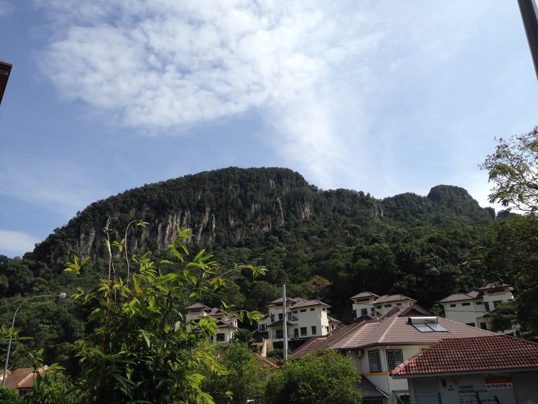
View of Tabur East from Taman Melawati. The ascent is from the left, up the gradually rising ridge and on to the first peak. The 2nd, 3rd and 4th peak can also be seen here, with the 4th peak being the high peak on the right of the picture. Just after the high peak, there is a drop and then a sharp cleft, just below the overhanging tree leaves. The cleft marks the end of the Tabur East trek.
After having climbed Tabur West a number of times, we felt confident, and curious enough to take on Tabur East! We started from our familiar starting point at the end of Jalan Kolam Air near the entrance of the Klang Gates Dam, even though there is a trailhead closer to Tabur East on the other side of the river. The path starts to the right of the Klang Gates Dam entrance where there are steps going down to the river bank along the Klang Gates fence. We crossed the open field and found a safe place to cross the Klang River (which is only a small stream at this point) to reach the other bank. There are a set of large water pipes which we followed towards the dam. There is a path on the right that leads straight up the hill. The path is marked with some signs.
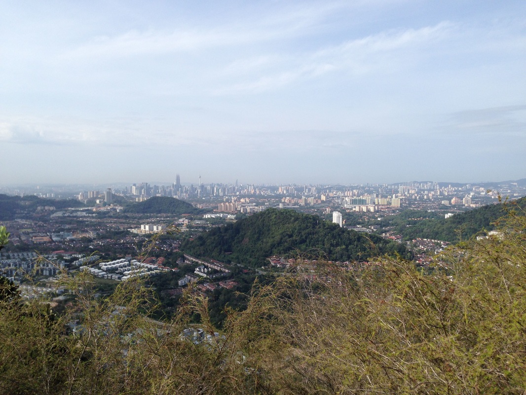
View of Kuala Lumpur with the Petronas twin towers clearly visible. Further back, the condominiums of Bangsar and Kiara are just about visible. The two hills in front of the city are Taman Melawati hill (front-right) and Wangsa Maju hill (mid-left)
The ascent is steep and requires quite some upper body strength to pull oneself up using the rock, roots and ropes for leverage. As we were climbing, we were rewarded with beautiful vistas of the KL skyline on one side and the Klang Gates reservoir on the other side. After just 1km of climbing, we reached the first peak. The ridge has fissures and is therefore not continuous. There are peaks and drops, sometimes quite deep ones. We counted at least 4 distinct peaks in total with the last one being the highest. Before reaching the last peak, we had to descend down to the forest level (the higher parts of the ridge are either treeless or is sparsely populated with trees) and then climb up again on a very steep 50m rock wall. There are fixed ropes there to help the ascent/descent but please test the strength of the rope before placing your entire weight on them as some of the trees used to anchor the ropes look too weak to me. But there are sufficient rock/root toe holds for one to clamber up without the ropes if one chooses to do so.
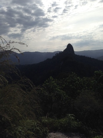 Majestic Tabur Extreme in silhouette
The highest peak was 355m in height according to my GPS. From the top, we could see, to our west, the ridge all the way to the peaks of Tabur West and beyond, an amazing sight. We could just about catch glimpses of trekkers with bright clothing making their way up the West peaks. And to our East, we could see an even higher and daunting peak further in the distance, the famous Tabur Extreme. It was quite some distance away with significant breaks in between. Clearly the path to that peak is not from where we were, but rather from the floor further to the east.
From the top, we went a further 0.2km in a somewhat descending path until we reached the edge of the peak, beyond which there was no further path. There was a sheer 50m drop that can only be descended by ropes and carabiners (or by flying). Further away beyond the chasm, some 30m or so, there was Tabur Far East, the next set of peaks on the ridge. But it was inaccessible from where we were. We turned back.
From the top, we went a further 0.2km in a somewhat descending path until we reached the edge of the peak, beyond which there was no further path. There was a sheer 50m drop that can only be descended by ropes and carabiners (or by flying). Further away beyond the chasm, some 30m or so, there was Tabur Far East, the next set of peaks on the ridge. But it was inaccessible from where we were. We turned back.
After climbing down from the last peak, we had a choice: we could either hike back the way we came, or take a branch to the left on the jungle "floor" between peak 4 and 3 and hike through the jungle to the villages near Taman Melawati. The jungle walk has some steep sandy/muddy slopes that must be navigated and may be a tougher walk on a wet day. We chose the jungle walk. It led to a T-junction near a village house. We turned right and followed the path to the village. We crossed the village and soon were on the Taman Melawati housing estate from where we strolled back to our car. The climb took us 2 hours and the descent another 1.5 hours.
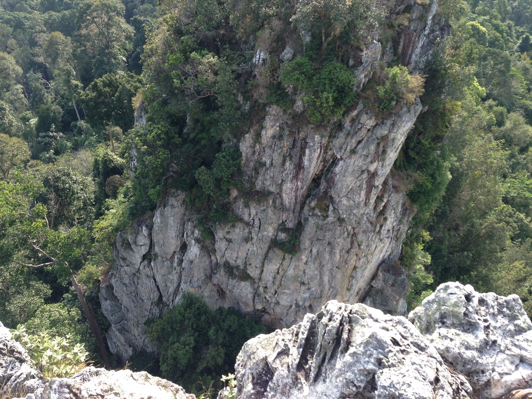
The sheer drop at the end of Peak 4. The next peak can be seen across the chasm.
East Tabur is not as crowded as West Tabur (we only came across 4 other groups even though it was a Sunday), but I imagine it could get busy on the "rock climbing" stretches and on the scenic picture-taking spots. Go early in the morning (7 - 8am) to avoid crowds, be very patient around the rock areas, look where you are stepping, don't get distracted by the scenery, and be extremely careful when posing for or taking pictures - a serious drop awaits you just inches behind where you are standing. And keep your distance from others, an accidental push or shove can throw you off balance and off the cliff. Be super careful at the end of the path - it's a a dead drop. And bring a hat as it gets very hot after 10 am as there is no tree cover on the ridge-top.
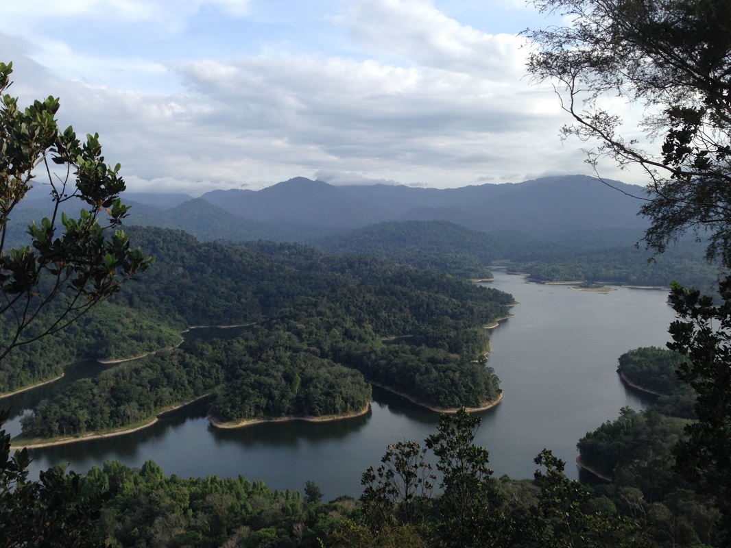
Klang Gates Reservoir with view of Titiwangsa range at the back. Gunung Bunga Buah is clearly visible as the tall triangular peak near the middle. On the right of it is Genting Highlands which is mostly obscured by clouds
Tabur West as seen from the peaks of Tabur East. The quartz ridge can be clearly seen in this picture
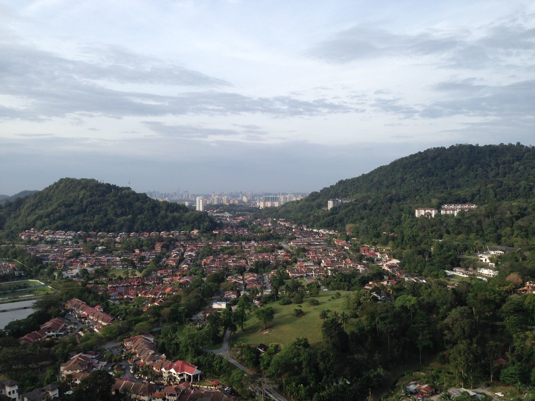
View of Taman Melawati and Bukit Melawati (on the left). The hill on the right protrudes from the midlle of Bukit Tabur West and I have not been able to find its name. I call it Bukit Mas after Taman Bukit Mas that is situated on one side of it. The top of the hill may be among the highest spot in the Federal Territory.
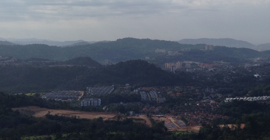
Kemensah hills (foreground), Ampang Hills (mid) and Bukit Belacan (back)
Trail Map and Data
| Location: | Taman Melawati |
| Distance: | 3.5 km |
| Duration: | 3.5 hrs |
| Average Speed: | 1.4 km/h |
| Min Elevation: | 69 m |
| Max Elevation: | 357 m |
| Vertical Up: | 333 m |
| Vertical Down: | 333 m |
Related Posts
- Bukit Tabur West
- Bukit Tabur Extreme

