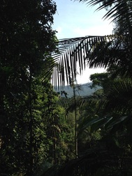
 View of the mountains across the valley from where we were on the trail
Malaysia, Kuala Lumpur, Ampang
261m | 10.7 km | 3.5 hours
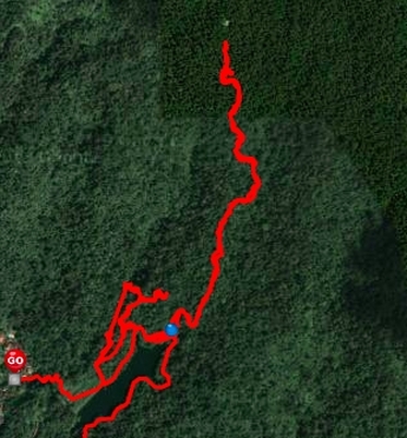
This was an attempt to follow the various trails leading from the Old Ampang Reservoir to its conclusion. It’s a continuation of our earlier reconnaissance of the lake and trailheads. We climbed to the level of the reservoir and proceeded to walk on a clock-wise circuit around the lake. First up was the trail that led westward from where the pier is. The one marked with "D”.
The trail initially runs level to the reservoir as a wide path. Just 50m from the lake, there is a another path to the right marked with red trail markers that heads up into the hills. This track is marked along the way with large signs showing "Bukit Kembara D”.
Our hope was that since it was heading in the general direction of the high northern peak, it would eventually lead us there. After about 500m of climbing, the marked trail levelled off and then started heading downwards steeply until it reached a level path next to a gully. The level path led back to the starting point of the D trail, making a roughly 1.2 km loop. The level path seems to have been created to run pipes from further up the hill down to where the reservoir is.
261m | 10.7 km | 3.5 hours
This was an attempt to follow the various trails leading from the Old Ampang Reservoir to its conclusion. It’s a continuation of our earlier reconnaissance of the lake and trailheads. We climbed to the level of the reservoir and proceeded to walk on a clock-wise circuit around the lake. First up was the trail that led westward from where the pier is. The one marked with "D”.
The trail initially runs level to the reservoir as a wide path. Just 50m from the lake, there is a another path to the right marked with red trail markers that heads up into the hills. This track is marked along the way with large signs showing "Bukit Kembara D”.
Our hope was that since it was heading in the general direction of the high northern peak, it would eventually lead us there. After about 500m of climbing, the marked trail levelled off and then started heading downwards steeply until it reached a level path next to a gully. The level path led back to the starting point of the D trail, making a roughly 1.2 km loop. The level path seems to have been created to run pipes from further up the hill down to where the reservoir is.
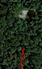 Magnified view of the white spot. Shows something resembling a square structure
After returning from the trip, I looked at Google Maps to see what might lay ahead of the path. I noticed a small area devoid of tree cover laying just 100m in front of where we turned back - you can see this as a white spot in the satellite picture. A close-up shows what seems like a square structure smack in the middle of think forest. What is that? It could be exposed rocks on a fast flowing stream (in the satellite view, there are signs of a stream flowing from left to right passing through that exposed spot). Or it could be some hut of some kind. Whatever it is, it is curious that it seems to be exactly where the path was leading to. Perhaps it is some form of infrastructure, a mast or monitoring equipment and the path was constructed as access to the structure.
After returning back to the lake we continued once more around the reservoir and finally came to the path that leads to the southern hill, known commonly as Bukit Kembara. We climbed up the steep path and then proceeded to descend on the other side of the hill into Taman Indah where we ended our journey.
A very curious trip which raised more questions that it did answers. Trails “C”, as well as the level path that started off “D” were obviously more than just jungle paths. Why were there pipes coming from higher up above the reservoir? The pipes under “D” are like what we have under our normal roads: large clay sewage pipe and small metal water supply pipe. Was this then a road that led to some substantial dwellings up in the hill but now abandonned?
 An exposed area devoid of tree cover lying just 100m in front of our turn back point, seen here as a white spot.
We did not find further marked trails leading up the hill, although we did make a short 100m attempt to ascend further up. But without anything to mark our trail, we decided not to go further for the moment.
Next we attempted the trail on the north side of the lake to see where that ends up. This is the trail with “C” marked. It was a wide track that went uphill following the stream that feeds the small waterfall on the reservoir. After about 0.7km, we reached some sort of a flat rest area with a table and plastic water bottles. The track beyond this point was full of undergrowth but still passable. We carried along for another 1 km trudging through thorny plants and bushes. After the flat rest area, the path was mostly level, hugging the hill contours, with the “northern peak" on our left and a deep stream valley on our right. And we could see that even though the path was full of undergrowth, it was not an ordinarily jungle trail - this was at one time a wide path, broad and flat enough to accommodate a bullock or horse cart. And quite some effort had obviously been expended on cutting the hill sides to make this path. At various points alone the way, we saw exposed pipes (plastic ones!) under the path.
Where does this path lead to? It headed due north in the general direction of the end of Jalan Zooview some 8 or 9km further north. At about the 1.8km from the start of this “C” trail, we came to a point where the undergrowth were so overgrown that we were stepping on the bushes and not the ground itself. A mis-step would mean the foot sinking a feet or more underneath the matted bushes and I found the going rather risky especially since we were on a ledge with a steep 30m drop on our right. Although the path went on as far as the eye could see (50m?), we decided to turn back.
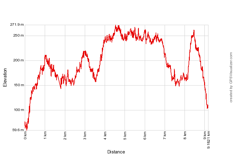
Trail Map and Data
| Location: | Ampang |
| Distance: | 9.2 km |
| Duration: | 2:50 hrs |
| Average Speed: | 3.0 km/h |
| Min Elevation: | 60 m |
| Max Elevation: | 272 m |
| Vertical Up: | 673 m |
| Vertical Down: | 638 m |