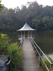
 The pier and band stand in the middle of the reservoir
Malaysia, Kuala Lumpur, Ampang
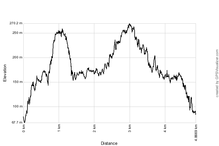
250m | 5.8 km | 3 hours
Although older pits, lakes and dams were constructed for mining purposes, it is believed that the "Ampang Impounding Reservoir" is the first water supply reservoir in Kuala Lumpur. Prior to that time, water for daily use was obtained from wells and rivers. Initial survey work for the reservoir started in 1888. The reservoir was built by damming one of the tributaries of the Ampang river, Sungai Kongsi Lapan, creating a long and narrow lake roughly 100m across and 500m long high on the hills of Ampang. Construction of the reservoir was completed in 1892. 10" pipes carried water from the reservoir to a storage tank on the "high hills behind the Residency". This is probably the water tank at Bukit Tunku, from where the water was piped to houses and businesses throughout Kuala Lumpur town. It would be an interesting project to visit the tanks and get a sense of its history and whether it's still in use today.
In only a few years thence, another, larger reservoir was constructed in nearby Bukit Belacan, seemingly taking on the moniker "Ampang Water Intake" and presumably in time rendering the earlier reservoir "Old". The new reservoir supplied water to a new set of tanks on top of Weld Hill from where the town was supplied with clean water. The Bukit Belacan intake and the Weld Hill tanks are still in operations today.
We started from the trailhead at Taman TAR near Kelab Darul Ehsan and climbed up to the reservoir. Came across what appeared to be filtration ponds, old corroded iron pipes, staff quarters and a disused access road along what was a rather steep climb. The reservoir itself was at an altitude of 170m and was completely encircled by a level track approximately1.8km in circumference and marked along the way as the "A" trail. We travelled anti-clockwise around the lake and found three clear paths, each marked "B", "C" and "D" leading further uphill from the lake track. The first trail ("B") led to the peak of Bukit Kembara, a 245m hill to the immediate south of the reservoir. The walk up the hill was very steep, but thankfully short. From the peak, the track continued southwards to an exit at Taman Indah. We turned back after the peak to avoid having to hike up Bukit Kembara again.
We started from the trailhead at Taman TAR near Kelab Darul Ehsan and climbed up to the reservoir. Came across what appeared to be filtration ponds, old corroded iron pipes, staff quarters and a disused access road along what was a rather steep climb. The reservoir itself was at an altitude of 170m and was completely encircled by a level track approximately1.8km in circumference and marked along the way as the "A" trail. We travelled anti-clockwise around the lake and found three clear paths, each marked "B", "C" and "D" leading further uphill from the lake track. The first trail ("B") led to the peak of Bukit Kembara, a 245m hill to the immediate south of the reservoir. The walk up the hill was very steep, but thankfully short. From the peak, the track continued southwards to an exit at Taman Indah. We turned back after the peak to avoid having to hike up Bukit Kembara again.
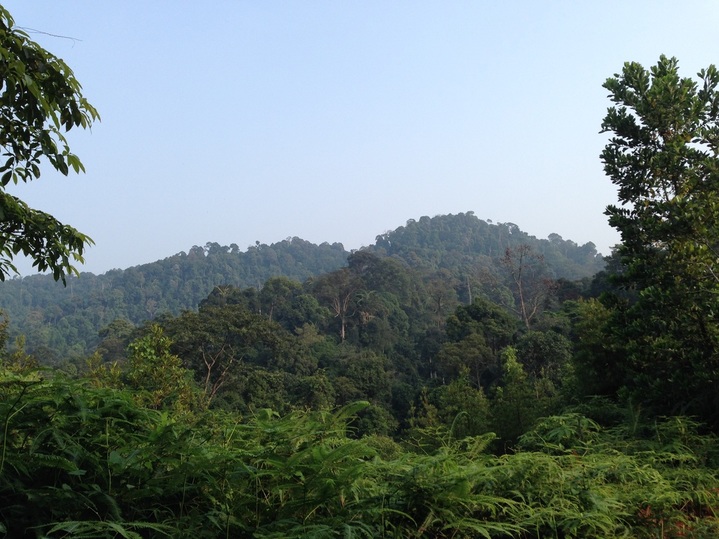
The highest peak among the hills surrounding the lake. Trail marked "C" appears to lead in the direction of this peak. Wonder what the hill is called
The second trail ("C") started at the north end of the lake and took us up a gradual climb along a creek that appears to be the main stream feeding the lake. After about 0.7 km, the trail becomes rather narrow and overgrown with undergrowth. It seems the trail continues all the way to an exit on the Zoo Negara road. This is quite plausible as there is a trail starting from the end of Jalan Zooview which heads southwards initially before turning northwards again to the waterfalls at the upper reaches of the Ampang River. That trail may well connect with the trail heading northwards from reservoir. If such is the case, I estimate the northwards trail to be about 9 km in length. Yet another project for a another day
Going further around the lake, on the west side, we came across the third trail, marked "D". It appeared to run along the contours of the hills leading around the Taman TAR enclave. However, just 20m from the lake, there is another trail that breaks off to the right and goes upwards. Judging from terrain maps, this break-off trail leads to the high northern hill that commands the whole Ampang area. We intend to hike this trail some time to find out where it leads to.
We returned to the lake path and continued anti-clockwise until we came back to the path that leads down to Taman TAR. There are several paths between TAR and the lake, but they are all end up in the same place.
A beautiful place nestled away in a scenic and cool jungle surrounding right next to the Ampang residential area. In the late 1800s, this place must have been all jungle with the nearest road being Jalan Ampang some 3 or 4 kilometres away. Jalan Kerja Ayer Lama (Old Water Works Road), judging by its name, must have been the access road built from Jalan Ampang to the reservoir. Today the road is a major road leading to many residential neighbourhoods, including Taman TAR, Ukay Heights and Ampang Jaya.
I have yet to find out what the hills are actually called. The "A" hill seems to be referred to as Bukit Kembara while the higher and more prominent "C" hill endures nameless.
The trailhead is located about 500m after passing Kelab Darul Ehsan, on the right side of the road. There are places to park right in front of the trailhead. One has to follow a small stream in between houses.

Old Ampang Reservoir with the unknown hill in the background
Trail Map and Data
View map fullscreen | View on Everytrail | Download GPX file
| Location: | Ampang |
| Distance: | 5.8 km |
| Duration: | 3 hrs |
| Average Speed: | 3.4 km/h |
| Min Elevation: | 100 m |
| Max Elevation: | 250 m |
| Vertical Up: | 300 m |
| Vertical Down: | 300 m |